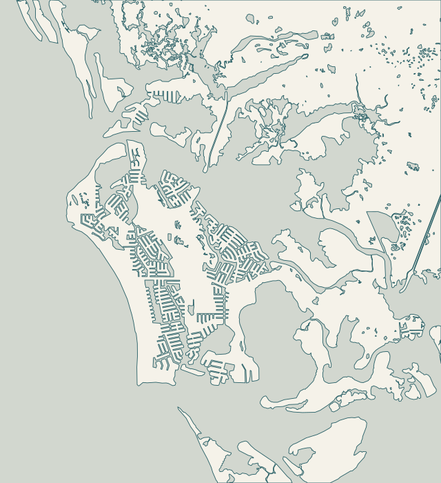
Choose the waterfront whose access and permit questions fit your property. These are research areas, not a promise of contractor availability.
Find your waterfront
Explore the coast. Find your starting point.
Local access, permit and shoreline questions for each area.
Full local guide
Choose a label to open local resources →Tap a community on the map or below ↗
Reference geography: Collier County GIS, U.S. Census Bureau and City of Marco Island road records. October 2026 snapshot; not a survey or navigation chart.
Your local starting point
Find your community.
Choose a guide for local maps, permit starting points and the records to gather for your property.
Old Marco is the island’s northern historic waterfront area. The city planning map places the Big Marco River along this side of the island, while the road dataset locates the Bald Eagle Drive reference used on our map. This guide concerns privately owned waterfront structures, not a claim that every historic property has the same seawall. On an established lot, docks, mature landscaping and adjoining walls can make a modest repair an access project as well as a structural one.
Collier Bay appears on the city’s comprehensive-plan map series on the northern side of Marco Island. The bridge reference identifies North Kendall Drive at the bay, but a neighborhood label does not tell you which bridges a particular canal route uses. Trace the route from the intended launch or loading point to the wall. Keep dock projections, vessel turning room and proposed toe protection in the same discussion.
The city describes the tidal bay between Tigertail Beach and Sand Dollar Island as a bird-feeding area. That setting is different from an engineered residential canal wall. The city bridge brochure separately identifies Clam Bay crossings at North Collier Boulevard, South Kendall Drive, Hernando Drive and Blackmore Drive. A property near Tigertail may need a bridge-route review, a habitat question or both; the street name alone does not determine the answer.
Hideaway Beach sits on the northwest side of Marco Island; this guide’s reference point follows the city’s Hideaway Circle East road geometry. The broader coast adjoins the Tigertail and Sand Dollar Island setting described in official coastal resources. Individual properties and shared waterfront facilities can have different ownership and access arrangements. Treat the map as orientation, then locate the legal work limits and existing structure on a survey.
The city bridge brochure identifies East Winterberry and the northbound and southbound Collier Boulevard spans at Smokehouse Bay. These named crossings help a marine contractor trace an approach, but do not certify that a proposed barge can reach every waterfront parcel. Where the project involves shared docks or several owners, the operating and access plan should identify who can authorize each work area.
Factory Bay & Marco River: the practical checklist
The city map series identifies the Big Marco River along the island’s northern waterfront. Its bridge brochure lists North Barfield at Factory Bay. Those sources establish useful geography and a route checkpoint; they do not establish a uniform wave load or soil condition for every property. Ask the project professional to evaluate the actual waterfront use, wall condition and working route.
This editorial area groups central island canal properties for planning; it is not a surveyed neighborhood boundary. The city bridge brochure identifies Goldenrod Avenue at Goldenrod Waterway, and the city road geometry supplies the map reference. Several residential turns may separate a property from open water. Ask the contractor to name the actual canal route instead of assuming that the nearest road bridge is the only constraint.
The city bridge brochure names West Winterberry at Shenandoah Waterway. That is useful for canal-route planning, while nearby beach-facing work raises different coastal questions. This guide groups the south-beach neighborhood and Shenandoah corridor for orientation without treating them as one permit overlay. The surveyed parcel, proposed footprint and equipment route determine which questions to take to the city and DEP.
The city plan identifies Caxambas Bay, and its bridge brochure places Caxambas Court at Roberts Bay. NOAA also maintains a historical datum sheet for Marco Island’s Caxambas Pass station. Nearby, FWC designates a Caxambas Pass Critical Wildlife Area with a seasonal closure. These sources help locate the planning issues, but none establishes a private parcel’s design elevation, barge permission or construction approval.
The city comprehensive-plan maps identify Barfield Bay and Key Marco on the island’s southeastern side. DEP’s regional material places the surrounding waters in a broader estuarine and aquatic-preserve context. This does not establish one regulatory boundary for every lot. Use a parcel survey and current agency maps to locate the existing structure, mangroves and proposed equipment or rock placement.
The city comprehensive-plan map explicitly shows Goodland outside Marco Island’s city limits. Collier Parks places Goodland Boating Park on Goodland Bay at 740 Palm Point Drive, with a two-lane ramp and access toward the Ten Thousand Islands. MarGood Harbor Park at 321 Pear Tree Avenue has a canoe and kayak launch. Those are useful public landmarks, but a paddling launch, boat ramp and permitted construction staging area are different facilities.
County Parks lists Isles of Capri Paddlecraft Park at 1295 Capri Boulevard and Isles of Capri Park at 139 Capri Boulevard. They are separate public reference locations, not this website’s offices or a promise of marine-construction access. The Rookery Bay reserve plan describes the surrounding estuarine region. A waterfront proposal should locate the existing structures, vegetation and intended route on the actual parcel’s plan.
Collier Parks lists Port of the Islands Marina at 525 Newport Drive, with an oversized single ramp and a 94-space parking facility. Those details locate a public access resource; they do not reserve it for a construction project. The Rookery Bay management plan discusses the Faka Union Bay watershed in the wider regional estuary. Establish the particular parcel, waterway route and proposed shoreline activity before assuming that island-city rules or access costs apply here.